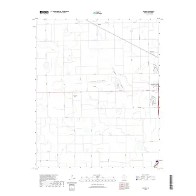
2019 Map of Wasson
USGS Topo · Published 2019About this map
Running Water Draw and Slaton Draw carve subtle paths across this section of the High Plains, illustrating the hydrological patterns of Hale County. The western outskirts of Plainview dominate the eastern edge of the map, where residential streets like Lometa Dr and Yucca Ter transition into the organized grid of rural county roads. This area reflects a mid-20th-century aviation footprint with the Quarterway Airport situated centrally among the agricultural plots. Small rural localities such as Boone and Wasson mark historic points of interest along the path of Olton Rd, showing how settlement and commerce followed these primary east-west corridors. The landscape is defined by its agricultural layout, punctuated by numerous small depressions and play lake basins typical of this Texas region.
Find a feature on this map
44 named features on this map. Tap any name to fly to it.
Don’t see what you’re looking for? This feature index may not catch every label — zoom into the map to look around manually.
Map Details
Editions of this 2019 Wasson Map
This is the sole edition of this map. No revisions or reprints were ever made.
Other maps of this area

1954 · Plainview
USGS Topo · 1:250,000

1958 · Plainview
USGS Topo · 1:250,000

1965 · Kress West
USGS Topo · 1:24,000

1965 · Edmonson
USGS Topo · 1:24,000

1965 · Wasson
USGS Topo · 1:24,000

1965 · Plainview
USGS Topo · 1:24,000

1968 · Halfway
USGS Topo · 1:24,000

1968 · Happy Union
USGS Topo · 1:24,000
1968 · Hale Center SW
USGS Topo · 1:24,000
1968 · Hale Center
USGS Topo · 1:24,000