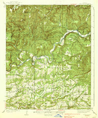
1939 Map of Watalula
USGS Topo · Published 1939About this map
The Mulberry River carves a winding path through the heart of the Ozark National Forest on this 1930s survey, where the river's horseshoe bends dictated the placement of early settlements and river crossings. In a time before modern bridging predominated, established fords like Milton Ford, Ham Ford, and Rock Creek Ford provided vital transit between the high ridges of Boles Mountain and White Rock Mountain. The landscape is a network of small, localized communities each anchored by institutions such as the Oak Ridge Sch and Enon Ch. Traces of the region's transport history are evident along the Wire Road, while small-scale industry is marked by a Coal Mine in the southern reaches of the quadrangle. For genealogists, the map preserves the locations of numerous family-named landmarks and rural burial grounds, including the Brewer Cem and Duncan Cem.
Find a feature on this map
106 named features on this map. Tap any name to fly to it.
Don’t see what you’re looking for? This feature index may not catch every label — zoom into the map to look around manually.
Map Details
Editions of this 1939 Watalula Map
3 editions found

Other maps of this area

1879 · Cravens
USGS Topo · 1:62,500

1887 · Magazine Mountain #1
USGS Topo · 1:62,500

1887 · Magazine Mountain #2
USGS Topo · 1:62,500

1887 · Watalula
USGS Topo · 1:62,500

1887 · Magazine Mountain
USGS Topo · 1:62,500

1890 · Magazine Mountain
USGS Topo · 1:125,000

1890 · Fort Smith
USGS Topo · 1:125,000

1898 · Winslow #4
USGS Topo · 1:62,500

1898 · Winslow
USGS Topo · 1:125,000

1901 · Winslow
USGS Topo · 1:125,000