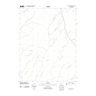
2010 Map of Water Canyon
USGS Topo · Published 2010About this map
Water Canyon and the surrounding high desert of Rio Blanco County define this landscape, where water management is critical to the local geography. Small catchment points like Johnson Draw Reservoir, Big Horse Draw Reservoir, and West Fourmile Reservoir punctuate a network of ephemeral drainages that channel seasonal runoff toward Douglas Creek. The transportation network is built around the rugged relief, with routes like Rangely Dragon Rd and County Rd-105 following the natural contours of the land. This map reveals the intricate drainage patterns of the western slope, from the aptly named No Name Draw to Little Vandamore Draw, illustrating how ranching and resource access depend on these specific topographic corridors.
Find a feature on this map
18 named features on this map. Tap any name to fly to it.
Don’t see what you’re looking for? This feature index may not catch every label — zoom into the map to look around manually.
Map Details
Editions of this 2010 Water Canyon Map
This is the sole edition of this map. No revisions or reprints were ever made.
Other maps of this area

1907 · Rangely
USGS Topo · 1:125,000

1910 · Rangely
USGS Topo · 1:125,000

1954 · Vernal
USGS Topo · 1:250,000

1956 · Grand Junction
USGS Topo · 1:250,000

1958 · Vernal
USGS Topo · 1:250,000

1959 · Grand Junction
USGS Topo · 1:250,000

1960 · Vernal
USGS Topo · 1:250,000

1960 · Grand Junction
USGS Topo · 1:250,000

1962 · Grand Junction
USGS Topo · 1:250,000
1962 · Rangely
USGS Topo · 1:24,000