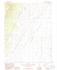
1985 Map of Water Gap NW
USGS Topo · Published 1986About this map
Garden Valley dominates the eastern half of this mid-1980s survey, representing a classic Great Basin landform of wide, open flats adjacent to steep mountain fronts. To the west, the Grant Range rises sharply, protected as part of the Humboldt National Forest. This interface of high peaks and valley floor is marked by drainage systems such as Rimrock Canyon, Spring Creek, and Bruno Creek, which disappear into the porous valley floor or a Dry Wash. High-desert land use is evidenced by several scattered Corrals and a Corral, alongside a solitary W.T. (water tank), illustrating the region's reliance on managed water points for livestock. The landscape is characterized by its transition from the densely contoured forested slopes to the expansive, minimally developed basin floor.
Find a feature on this map
13 named features on this map. Tap any name to fly to it.
Don’t see what you’re looking for? This feature index may not catch every label — zoom into the map to look around manually.
Map Details
Editions of this 1985 Water Gap NW Map
This is the sole edition of this map. No revisions or reprints were ever made.
Other maps of this area

1956 · Lund
USGS Topo · 1:250,000

1960 · Lund
USGS Topo · 1:250,000

1964 · Troy Canyon
USGS Topo · 1:62,500

1964 · Forest Home
USGS Topo · 1:62,500

1985 · Adaven
USGS Topo · 1:24,000

1985 · Water Gap East
USGS Topo · 1:24,000
1985 · Wadsworth Ranch
USGS Topo · 1:24,000
1985 · Water Gap West
USGS Topo · 1:24,000
1985 · Water Gap NE
USGS Topo · 1:24,000

1988 · Quinn Canyon Range
USGS Topo · 1:100,000