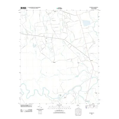
2012 Map of Wateree
USGS Topo · Published 2012About this map
Eastover and Kingville anchor the northern reaches of this Richland County landscape, situated where the high ground begins its descent toward the great river bottomlands. The southern half of the map is dominated by the meandering course of the Congaree River, which carves deep bends like the Devils Elbow and creates a complex network of seasonal waterways including Running Lake, Big Lake, and Little Lake. This area reflects a long history of river-dependent settlement and land use, evidenced by the scattered burial grounds that serve as landmarks for local families, including Joyner Cemetery and Goodin Cemetery.
Find a feature on this map
61 named features on this map. Tap any name to fly to it.
Don’t see what you’re looking for? This feature index may not catch every label — zoom into the map to look around manually.
Map Details
Editions of this 2012 Wateree Map
This is the sole edition of this map. No revisions or reprints were ever made.
Other maps of this area

1943 · Eastover
USGS Topo · 1:62,500

1946 · Elloree
USGS Topo · 1:62,500

1946 · St. Matthews
USGS Topo · 1:62,500

1948 · Hopkins
USGS Topo · 1:62,500

1953 · Poinsett State Park
USGS Topo · 1:24,000

1953 · Eastover
USGS Topo · 1:24,000

1953 · Wedgefield
USGS Topo · 1:24,000
1953 · Congaree
USGS Topo · 1:24,000

1953 · Gadsden
USGS Topo · 1:24,000

1953 · Wateree
USGS Topo · 1:24,000