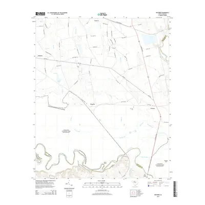
2014 Map of Wateree
USGS Topo · Published 2014About this map
Congaree National Park Wilderness dominates the lower half of this landscape, preserving the floodplain where the Congaree River meanders toward its confluence with the Wateree River. The terrain is defined by a complex network of oxbow lakes and backwaters, including Running Lake, Big Lake, and the winding Bates Old River. This hydrological environment contrasts sharply with the upland settlements to the north, such as Eastover and Gadsden, which are connected by a grid of rural routes including Bluff Rd and Old Eastover Rd. Genealogical interest is found in small family and community burial sites like Joyner Cem and Tom Seay Cem, while the historic crossing at Fort Motte Bridge marks the southern boundary between Richland and Calhoun counties. The map captures a moment in the early 21st century where the preserved wilderness of the river bottoms meets the agricultural and residential outskirts of the Kingville area.
Find a feature on this map
66 named features on this map. Tap any name to fly to it.
Don’t see what you’re looking for? This feature index may not catch every label — zoom into the map to look around manually.
Map Details
Editions of this 2014 Wateree Map
This is the sole edition of this map. No revisions or reprints were ever made.
Other maps of this area

1943 · Eastover
USGS Topo · 1:62,500

1946 · Elloree
USGS Topo · 1:62,500

1946 · St. Matthews
USGS Topo · 1:62,500

1948 · Hopkins
USGS Topo · 1:62,500

1953 · Poinsett State Park
USGS Topo · 1:24,000

1953 · Eastover
USGS Topo · 1:24,000

1953 · Wedgefield
USGS Topo · 1:24,000
1953 · Congaree
USGS Topo · 1:24,000

1953 · Gadsden
USGS Topo · 1:24,000

1953 · Wateree
USGS Topo · 1:24,000