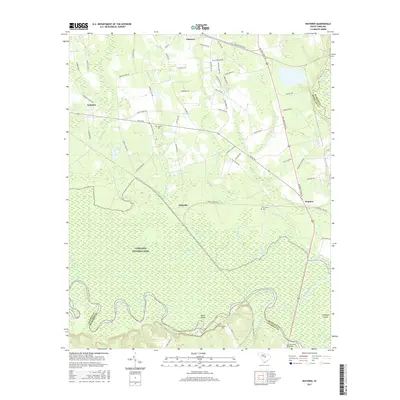
2017 Map of Wateree
USGS Topo · Published 2017About this map
Congaree National Park anchors this map of the South Carolina Midlands, where the vast floodplain of the Congaree River meets the Wateree River at their historic confluence. The landscape is defined by the shifting waters of the Congaree, featuring dramatic oxbows like Devils Elbow and secluded water bodies including Big Lake, Running Lake, and the Blue Hole. North of the swamp, the terrain transitions into agricultural and residential lands centered on the small settlements of Eastover, Gadsden, and Kingville. Local heritage is preserved in family landmarks and resting places such as Joyner Cem, Tom Seay Cem, and Goodin Cem. The road network, including the historic McCords Ferry Rd and Bluff Rd, traces the higher ground above the Wateree Swamp, connecting these rural communities to the critical crossing at Fort Motte Bridge.
Find a feature on this map
77 named features on this map. Tap any name to fly to it.
Don’t see what you’re looking for? This feature index may not catch every label — zoom into the map to look around manually.
Map Details
Editions of this 2017 Wateree Map
This is the sole edition of this map. No revisions or reprints were ever made.
Other maps of this area

1943 · Eastover
USGS Topo · 1:62,500

1946 · Elloree
USGS Topo · 1:62,500

1946 · St. Matthews
USGS Topo · 1:62,500

1948 · Hopkins
USGS Topo · 1:62,500

1953 · Poinsett State Park
USGS Topo · 1:24,000

1953 · Eastover
USGS Topo · 1:24,000

1953 · Wedgefield
USGS Topo · 1:24,000
1953 · Congaree
USGS Topo · 1:24,000

1953 · Gadsden
USGS Topo · 1:24,000

1953 · Wateree
USGS Topo · 1:24,000