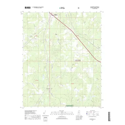
2018 Map of Waterford
USGS Topo · Published 2018About this map
Waterford and the surrounding Marshall County countryside are depicted here as they appeared in 2018, characterized by a mix of agricultural land and the wooded stretches of the Holly Springs National Forest. The landscape is dotted with several family-named and community burial grounds, including the Waterford Cem, Sauls Chapel Cem, and Pegues Cem, which offer significant touchpoints for local genealogical research. Small settlements like Gilton and Waites sit along a network of rural routes such as Potts Camp Rd and Old Hwy 7 S. Water features like Spring Lake, Lake Daroma, and Little Spring Cr drain the undulating terrain, while the Farm Service Agency Interest of Mississippi indicates specific land management or conservation areas within this section of the state.
Find a feature on this map
49 named features on this map. Tap any name to fly to it.
Don’t see what you’re looking for? This feature index may not catch every label — zoom into the map to look around manually.
Map Details
Editions of this 2018 Waterford Map
This is the sole edition of this map. No revisions or reprints were ever made.
Other maps of this area

1944 · Tyro
USGS Topo · 1:62,500

1944 · Potts Camp
USGS Topo · 1:62,500

1945 · Potts Camp
USGS Topo · 1:62,500

1948 · Byhalia
USGS Topo · 1:62,500

1953 · Holly Springs
USGS Topo · 1:62,500

1956 · Tupelo
USGS Topo · 1:250,000

1958 · Tupelo
USGS Topo · 1:250,000

1964 · Waterford
USGS Topo · 1:24,000

1964 · Holly Springs SE
USGS Topo · 1:24,000
1965 · Holly Springs
USGS Topo · 1:24,000