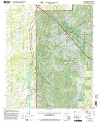
2000 Map of Waterford
USGS Topo · Published 2003About this map
Waterford and the crossroads at Waites anchor this landscape within Marshall County at the turn of the millennium. The area is defined by the expansive Holly Springs National Forest, which blankets much of the eastern and southern terrain. Near the center, Wall Doxey State Park provides a focused recreational hub around Spring Lake and Lake Danoria. The map reveals a deeply rooted community structure, evidenced by a dense network of country churches and family-named cemeteries such as Beverly Chapel Ch, Jones Grove Ch, and Sauls Chapel Cem. Transportation is dominated by Old Highway 7 and a series of rural routes like Jones Grove Rd and Bethlehem Road that navigate the drainages of Nunnally Creek and Chew Creek. This survey captures the transition of the region into a protected timber and recreation area while maintaining its character as a collection of small upland settlements.
Find a feature on this map
39 named features on this map. Tap any name to fly to it.
Don’t see what you’re looking for? This feature index may not catch every label — zoom into the map to look around manually.
Map Details
Editions of this 2000 Waterford Map
This is the sole edition of this map. No revisions or reprints were ever made.
Other maps of this area

1944 · Tyro
USGS Topo · 1:62,500

1944 · Potts Camp
USGS Topo · 1:62,500

1945 · Potts Camp
USGS Topo · 1:62,500

1948 · Byhalia
USGS Topo · 1:62,500

1953 · Holly Springs
USGS Topo · 1:62,500

1956 · Tupelo
USGS Topo · 1:250,000

1958 · Tupelo
USGS Topo · 1:250,000

1964 · Waterford
USGS Topo · 1:24,000

1964 · Holly Springs SE
USGS Topo · 1:24,000
1965 · Holly Springs
USGS Topo · 1:24,000