
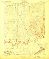
1916 Map of Waterford
USGS Topo · Published 1916About this map
The Tuolumne River winds through the southern edge of this Central Valley landscape, defining a region where the transition from ranching to irrigated agriculture is clearly visible. The vast Thompson Rancho occupies the northwest corner, contrasting with the emerging grid of irrigation infrastructure like the Modesto Canal and No 2 Lateral. This 1914 survey, published by the U.S. Geological Survey, illustrates the early 20th-century dependence on rail and river, with the Southern Pacific line and its Oakdale Branch connecting the grain and fruit-growing districts.
Find a feature on this map
14 named features on this map. Tap any name to fly to it.
Don’t see what you’re looking for? This feature index may not catch every label — zoom into the map to look around manually.
Map Details
Editions of this 1916 Waterford Map
2 editions found
Other maps of this area

1915 · Oakdale
USGS Topo · 1:31,680

1915 · Paulsell
USGS Topo · 1:31,680

1915 · Thalheim
USGS Topo · 1:31,680

1916 · Montpellier
USGS Topo · 1:31,680

1916 · Riverbank
USGS Topo · 1:31,680

1916 · Denair
USGS Topo · 1:31,680

1916 · Ceres
USGS Topo · 1:31,680

1916 · Copperopolis
USGS Topo · 1:62,500

1939 · Modesto East
USGS Topo · 1:62,500

1942 · Farmington
USGS Topo · 1:62,500