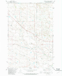
1981 Map of Waterhole Creek
USGS Topo · Published 1981About this map
Waterhole Creek and its neighboring drainages, including Corral Creek and Buffalo Creek, define the landscape of this high plains region straddling the Montana and North Dakota border in the early 1980s. The area maintains a sparse, agrarian character centered around landmarks like the Fertile Prairie Cem and the Fertile Prairie Sch. Industrial and resource-based activity is evidenced by scattered infrastructure, such as a Drill Hole in the northwest and Gravel Pits in the southeast. Transport and commerce are anchored by the Chicago Milwaukee St Paul and Pacific railroad, which cuts through the southern portion of the quadrangle. The map also records numerous water sources essential for life on the plains, including a Flowing Well and various springs, highlighting the vital relationship between the terrain and its limited water supply.
Find a feature on this map
18 named features on this map. Tap any name to fly to it.
Don’t see what you’re looking for? This feature index may not catch every label — zoom into the map to look around manually.
Map Details
Editions of this 1981 Waterhole Creek Map
This is the sole edition of this map. No revisions or reprints were ever made.
Other maps of this area

1953 · Miles City
USGS Topo · 1:250,000

1953 · Dickinson
USGS Topo · 1:250,000

1957 · Dickinson
USGS Topo · 1:250,000

1957 · Miles City
USGS Topo · 1:250,000

1958 · Miles City
USGS Topo · 1:250,000

1973 · Kid Creek
USGS Topo · 1:24,000

1980 · Pretty Butte
USGS Topo · 1:24,000

1980 · Marmarth
USGS Topo · 1:24,000

1981 · Webster NW
USGS Topo · 1:24,000

1981 · Baker
USGS Topo · 1:100,000