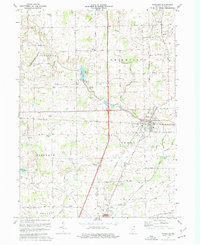
1973 Map of Waterloo
USGS Topo · Published 1974About this map
Waterloo and the northern edge of Auburn anchor this DeKalb County landscape during the early 1970s, where the Penn Central railroad cuts a straight line through the heart of the settlement. The map reveals a rural economy shifting toward modern infrastructure, evidenced by the Auburn Airport and a prominent Substation positioned near the rail lines. Small agricultural communities like Sedan persist, identified by their own Sedan Cemetery and local landmarks like Maple Grove Church.
Find a feature on this map
54 named features on this map. Tap any name to fly to it.
Don’t see what you’re looking for? This feature index may not catch every label — zoom into the map to look around manually.
Map Details
Editions of this 1973 Waterloo Map
2 editions found
Other maps of this area

1939 · Hamilton
USGS Topo · 1:24,000

1942 · Ashley
USGS Topo · 1:24,000

1942 · Stroh
USGS Topo · 1:24,000

1948 · Hamilton
USGS Topo · 1:24,000

1953 · Fort Wayne
USGS Topo · 1:250,000

1955 · Corunna
USGS Topo · 1:24,000

1956 · Fort Wayne
USGS Topo · 1:250,000

1957 · Auburn
USGS Topo · 1:24,000

1957 · Waterloo
USGS Topo · 1:24,000

1957 · Garrett
USGS Topo · 1:24,000