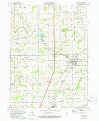
1973 Map of Waterloo
USGS Topo · Published 1979About this map
Waterloo serves as the primary hub of this DeKalb County landscape, where the Penn Central rail lines intersect a network of county roads. The settlement of Sedan lies to the west, situated among a complex drainage system defined by the Mc Cullough Ditch and Leins Ditch. The presence of the County High Sch and a nearby Picnic Area reflects the civic center of the era, while several historic religious and burial sites are scattered across the townships, including St Michaels Ch, Maple Grove Ch, and the Tamarack Cem.
Find a feature on this map
57 named features on this map. Tap any name to fly to it.
Don’t see what you’re looking for? This feature index may not catch every label — zoom into the map to look around manually.
Map Details
Editions of this 1973 Waterloo Map
2 editions found
Other maps of this area

1939 · Hamilton
USGS Topo · 1:24,000

1942 · Ashley
USGS Topo · 1:24,000

1942 · Stroh
USGS Topo · 1:24,000

1948 · Hamilton
USGS Topo · 1:24,000

1953 · Fort Wayne
USGS Topo · 1:250,000

1955 · Corunna
USGS Topo · 1:24,000

1956 · Fort Wayne
USGS Topo · 1:250,000

1957 · Auburn
USGS Topo · 1:24,000

1957 · Waterloo
USGS Topo · 1:24,000

1957 · Garrett
USGS Topo · 1:24,000