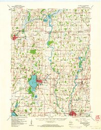
1959 Map of Waterloo
USGS Topo · Published 1961About this map
Aztalan State Park and the surrounding archaeological landscape sit along the winding Crawfish River, serving as a focal point for this late-1950s survey of Jefferson County. The river network, including the Rock River and Beaverdam River, dictates the placement of long-standing communities like Milford, Hubbleton, and Johnson Creek. The era's infrastructure is prominently displayed through the intersection of the Chicago Milwaukee ST Paul And Pacific and the Chicago And North Western railroads, which facilitated the region's agricultural and industrial movement. Local life is documented through numerous rural institutions, such as St Wenceslaus Ch, Mamre Ch, and a dense network of one-room schoolhouses like Plainview Sch and Hyer Sch. On the shores of Rock Lake, the city of Lake Mills features Lakeside Park and a Fish Hatchery, while further south, the city of Jefferson shows its development around the Fairground and Jefferson Junction.
Find a feature on this map
90 named features on this map. Tap any name to fly to it.
Don’t see what you’re looking for? This feature index may not catch every label — zoom into the map to look around manually.
Map Details
Editions of this 1959 Waterloo Map
This is the sole edition of this map. No revisions or reprints were ever made.
Other maps of this area

1890 · Sun Prairie
USGS Topo · 1:62,500

1890 · Stoughton
USGS Topo · 1:62,500

1891 · Waterloo
USGS Topo · 1:62,500

1891 · Koshkonong
USGS Topo · 1:62,500

1892 · Watertown
USGS Topo · 1:62,500

1892 · Whitewater
USGS Topo · 1:62,500

1893 · Whitewater
USGS Topo · 1:62,500

1894 · Waterloo
USGS Topo · 1:62,500

1894 · Watertown
USGS Topo · 1:62,500

1894 · Koshkonong
USGS Topo · 1:62,500