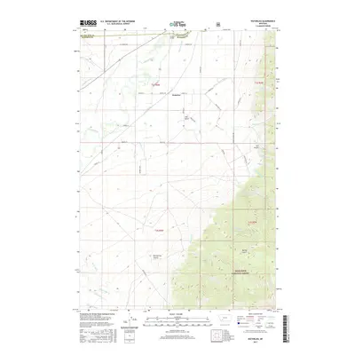
2017 Map of Waterloo
USGS Topo · Published 2017About this map
Waterloo sits at a critical intersection of water and terrain in this 2017 survey, positioned between the braiding channels of the Jefferson River and the rising slopes of the Deerlodge National Forest. The landscape is defined by its complex irrigation network, including the Parrot Ditch, Creeklyn Ditch, and Cornforth Ditch, which support agricultural activity across a high terrace known as The Bench. This area reveals the persistent importance of early transport routes, with Old Stage Rd winding south toward the rugged topography of Hellroaring Canyon and Bumby Gulch. The northern section is dominated by the river's influence, marked by Parsons Slough and Parsons Bridge, where the boundaries of Silver Bow, Madison, and Jefferson Counties converge. As the terrain ascends to the east, numerous named drainages like Mill Canyon and Brooks Cr cut through the foothills, illustrating the transition from valley floor to forest highlands.
Find a feature on this map
46 named features on this map. Tap any name to fly to it.
Don’t see what you’re looking for? This feature index may not catch every label — zoom into the map to look around manually.
Map Details
Editions of this 2017 Waterloo Map
This is the sole edition of this map. No revisions or reprints were ever made.
Other maps of this area

1893 · Dillon
USGS Topo · 1:250,000

1955 · Dillon
USGS Topo · 1:250,000

1957 · Dillon
USGS Topo · 1:250,000

1958 · Dillon
USGS Topo · 1:250,000

1960 · Twin Bridges
USGS Topo · 1:62,500

1960 · Waterloo
USGS Topo · 1:62,500

1962 · Dillon
USGS Topo · 1:250,000
1963 · Whitehall
USGS Topo · 1:24,000

1963 · Vendome
USGS Topo · 1:24,000
1963 · Grace
USGS Topo · 1:24,000