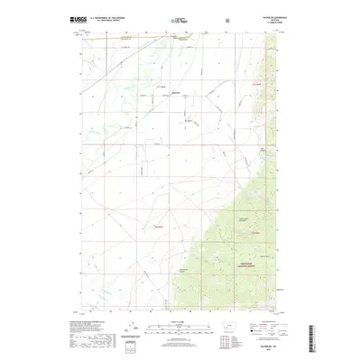
2020 Map of Waterloo
USGS Topo · Published 2020About this map
The Waterloo settlement sits at a vital geographic junction where the Jefferson River valley meets the rising slopes of the Tobacco Root Mountains. This landscape is defined by its complex water management system, featuring an extensive network of irrigation channels like Parrot Ditch, Creeklyn Ditch, and Duffy Ditch that sustain the valley floor. To the south and east, the terrain climbs sharply into the Deerlodge National Forest, where deep ravines like Hellroaring Canyon and Mill Canyon cut through the high country. Historical transportation routes are evident in the path of the Old Stage Rd, which winds through the foothills, and the crossing at Parsons Bridge. The map captures the distinct contrast between the managed agricultural 'bench' lands and the high-elevation wilderness of the Antimony Cr drainage.
Find a feature on this map
51 named features on this map. Tap any name to fly to it.
Don’t see what you’re looking for? This feature index may not catch every label — zoom into the map to look around manually.
Map Details
Editions of this 2020 Waterloo Map
This is the sole edition of this map. No revisions or reprints were ever made.
Other maps of this area

1893 · Dillon
USGS Topo · 1:250,000

1955 · Dillon
USGS Topo · 1:250,000

1957 · Dillon
USGS Topo · 1:250,000

1958 · Dillon
USGS Topo · 1:250,000

1960 · Twin Bridges
USGS Topo · 1:62,500

1960 · Waterloo
USGS Topo · 1:62,500

1962 · Dillon
USGS Topo · 1:250,000
1963 · Whitehall
USGS Topo · 1:24,000

1963 · Vendome
USGS Topo · 1:24,000
1963 · Grace
USGS Topo · 1:24,000