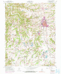
1954 Map of Waterloo
USGS Topo · Published 1990About this map
Waterloo serves as the focal point of this mid-century survey of Monroe County, showing the city's residential grid and the Illinois Central Gulf railroad line that anchored the local economy. The landscape south and west of the city is defined by a series of small, rural clusters and educational sites, including Wartburg, Burksville, and the Old Rock Sch. This era captures the transition of the region from a strictly agrarian patchwork to one with more diverse land uses, evidenced by the presence of Camp Vandeventer and the Dugan Airfield tucked between the drainages of Fountain Creek. Geologic and topographic detail is high, especially near the sinkhole-scattered terrain of Hesterburg, while religious life is well-documented through landmarks like St Johns Ch, Salem Ch, and Holy Cross Sch.
Find a feature on this map
29 named features on this map. Tap any name to fly to it.
Don’t see what you’re looking for? This feature index may not catch every label — zoom into the map to look around manually.
Map Details
Editions of this 1954 Waterloo Map
4 editions found
Other maps of this area

1910 · Waterloo
USGS Topo · 1:62,500

1912 · Kimmswick
USGS Topo · 1:62,500

1913 · Waterloo
USGS Topo · 1:62,500

1915 · Renault
USGS Topo · 1:62,500

1915 · Crystal City
USGS Topo · 1:62,500

1916 · Kimmswick
USGS Topo · 1:62,500

1940 · Renault
USGS Topo · 1:62,500

1948 · Kimmswick
USGS Topo · 1:62,500

1949 · Saint Louis
USGS Topo · 1:250,000

1949 · Crystal City
USGS Topo · 1:62,500