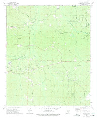
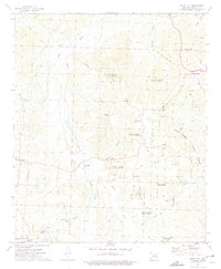
1973 Map of Waterloo
USGS Topo · Published 1975About this map
Industrial and rural landscapes intersect in this 1970s survey of southern Arkansas, where the Irma Oil Field and Nevark Oil Field define the local economy. A network of heavy infrastructure including a Refinery and multiple pipelines runs through the timberlands, connecting scattered settlements like Waterloo and Nevark. Historical routes such as the Washington Post Road and Reader Road provide a glimpse into the region's transportation development, while the extensive Poison Springs State Forest occupies much of the eastern terrain.
Find a feature on this map
41 named features on this map. Tap any name to fly to it.
Don’t see what you’re looking for? This feature index may not catch every label — zoom into the map to look around manually.
Map Details
Editions of this 1973 Waterloo Map
This is the sole edition of this map. No revisions or reprints were ever made.
Other maps of this area

1901 · Gurdon
USGS Topo · 1:125,000

1953 · El Dorado
USGS Topo · 1:250,000

1957 · El Dorado
USGS Topo · 1:250,000

1958 · El Dorado
USGS Topo · 1:250,000

1960 · El Dorado
USGS Topo · 1:250,000

1968 · Lamartine
USGS Topo · 1:24,000
1969 · Stephens
USGS Topo · 1:24,000
1969 · Magnolia NW
USGS Topo · 1:24,000
1973 · Chidester
USGS Topo · 1:24,000
1973 · Bluff City
USGS Topo · 1:24,000