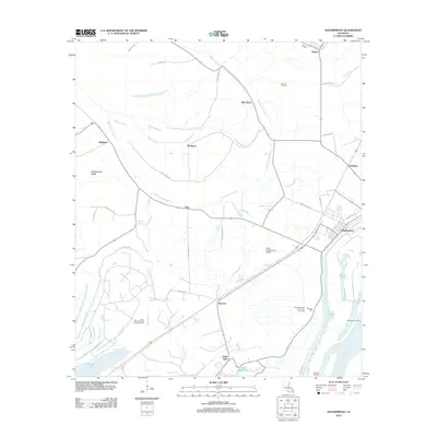
2012 Map of Waterproof
USGS Topo · Published 2012About this map
The town of Waterproof serves as the focal point of this Mississippi River delta landscape, where the town's position on the western bank is defined by the massive levee system and the Gorton Chute channel. This 2012 survey reveals an economy deeply tied to both the land and the subsurface, featuring extensive energy infrastructure like the Helena Oil Field and the Northeast Lake Saint John Gas Field. The alluvial plain is heavily bifurcated by a network of bayous, including Big Choctaw Bayou and Buffalo Bayou, which dictate the placement of rural settlements such as Highland, Richland, and Azucena. For the researcher, the map preserves the exact locations of local landmarks including Winona Cem and Helena Cem, alongside small agricultural airstrips like the Ag Air Incorporated Airport that serve the surrounding fields.
Find a feature on this map
44 named features on this map. Tap any name to fly to it.
Don’t see what you’re looking for? This feature index may not catch every label — zoom into the map to look around manually.
Map Details
Editions of this 2012 Waterproof Map
This is the sole edition of this map. No revisions or reprints were ever made.
Other maps of this area

1909 · Delta Bridge
USGS Topo · 1:24,000

1921 · Natchez
USGS Topo · 1:48,000

1922 · Natchez
USGS Topo · 1:62,500

1939 · Red Gum
USGS Topo · 1:62,500

1939 · Natchez
USGS Topo · 1:62,500

1939 · Locust Ridge
USGS Topo · 1:62,500

1941 · Sicily Island
USGS Topo · 1:62,500

1953 · Natchez
USGS Topo · 1:250,000

1956 · Natchez
USGS Topo · 1:250,000

1957 · Sicily Island
USGS Topo · 1:62,500