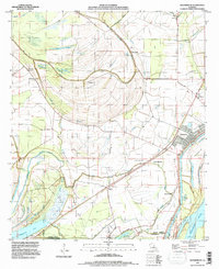
1994 Map of Waterproof
USGS Topo · Published 1997About this map
Mississippi River waters and the complex meanders of the Tensas River define this stretch of the Louisiana delta at the edge of Tensas and Concordia Parishes. The landscape is a testament to the region's agricultural and hydrologic history, dominated by large estates like Arcola Plantation and Winona Plantation. A sophisticated network of levees protects these fertile lowlands, which are punctuated by numerous oxbow lakes and bayous, including Big Choctaw Bayou and Muddy Bayou. The town of Waterproof stands as the primary settlement, its name a reminder of the constant dance with the river. Smaller communities and rural hubs such as Azucena, Richland, and Barcelona are scattered across the alluvial plain, often associated with local landmarks like the Helena Cem. The presence of an Oil and Gas Field and several landing strips suggests a landscape defined by both traditional farming and modern resource extraction.
Find a feature on this map
44 named features on this map. Tap any name to fly to it.
Don’t see what you’re looking for? This feature index may not catch every label — zoom into the map to look around manually.
Map Details
Editions of this 1994 Waterproof Map
This is the sole edition of this map. No revisions or reprints were ever made.
Other maps of this area

1909 · Delta Bridge
USGS Topo · 1:24,000

1921 · Natchez
USGS Topo · 1:48,000

1922 · Natchez
USGS Topo · 1:62,500

1939 · Red Gum
USGS Topo · 1:62,500

1939 · Natchez
USGS Topo · 1:62,500

1939 · Locust Ridge
USGS Topo · 1:62,500

1941 · Sicily Island
USGS Topo · 1:62,500

1953 · Natchez
USGS Topo · 1:250,000

1956 · Natchez
USGS Topo · 1:250,000

1957 · Sicily Island
USGS Topo · 1:62,500