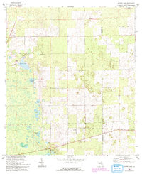
1968 Map of Waters Lake
USGS Topo · Published 1993About this map
The Gilchrist and Alachua County line bisects this landscape, where the town of Newberry sits at the southeastern edge. This region is characterized by an intricate network of small ponds and wetlands, including Christmas Lake, Fivemile Pond, and Knighting Lake, which dot the terrain between stretches of woodland. An Old Railroad Grade cuts north-south through the center of the map, serving as a reminder of the area's earlier industrial and transport corridors.
Find a feature on this map
24 named features on this map. Tap any name to fly to it.
Don’t see what you’re looking for? This feature index may not catch every label — zoom into the map to look around manually.
Map Details
Editions of this 1968 Waters Lake Map
3 editions found
Other maps of this area

1954 · Gainesville
USGS Topo · 1:250,000

1958 · Gainesville
USGS Topo · 1:250,000

1959 · Gainesville
USGS Topo · 1:250,000

1962 · High Springs
USGS Topo · 1:24,000

1968 · Newberry SW
USGS Topo · 1:24,000

1968 · Waters Lake
USGS Topo · 1:24,000
1968 · Archer
USGS Topo · 1:24,000

1968 · Newberry
USGS Topo · 1:24,000

1968 · Fourmile Lake
USGS Topo · 1:24,000

1968 · Trenton
USGS Topo · 1:24,000