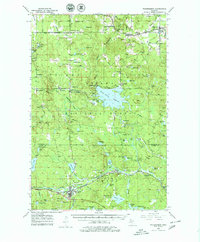
1952 Map of Watersmeet
USGS Topo · Published 1979About this map
Watersmeet serves as the focal point of this mid-century Western Upper Peninsula landscape, where the Chicago and North Western rail line intersects with a wilderness shaped by the timber and water of the Ottawa National Forest. The geography is defined by the Middle Branch Ontonagon River and its dramatic features like Agate Falls and the significant Bond Falls Flowage. Small rural hubs such as Trout Creek, Agate, and Paulding are connected by a network of gravel roads and rail spurs, reflecting an era before modern highway expansion. Local life is anchored by landmarks like the Maple Grove Sch and Agate Cem, while the interior remains a dense assembly of named lakes and ponds including Erickson Lake and Johnson Lake, highlighting the region's legacy of logging and outdoor recreation.
Find a feature on this map
93 named features on this map. Tap any name to fly to it.
Don’t see what you’re looking for? This feature index may not catch every label — zoom into the map to look around manually.
Map Details
Editions of this 1952 Watersmeet Map
5 editions found
Other maps of this area

1938 · Phelps
USGS Topo · 1:48,000

1946 · Star Lake
USGS Topo · 1:48,000

1949 · Rockland
USGS Topo · 1:62,500

1950 · Phelps
USGS Topo · 1:48,000

1950 · Star Lake
USGS Topo · 1:48,000

1951 · Rockland
USGS Topo · 1:62,500

1952 · Watersmeet
USGS Topo · 1:62,500

1952 · Thayer
USGS Topo · 1:62,500

1954 · Rousseau
USGS Topo · 1:62,500

1954 · Kenton
USGS Topo · 1:62,500