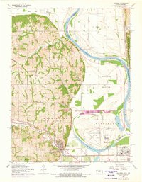
1961 Map of Wathena
USGS Topo · Published 1973About this map
Wathena and the surrounding river bottoms define this landscape where the Missouri River forms a sharp, meandering boundary between Kansas and Missouri. The terrain shifts from the high, dissected bluffs of Burr Oak and Washington townships to the expansive, low-lying alluvial plains of French Bottom and Gladden Bottom. This 1961 survey, updated with 1972 aerial revisions, documents a critical transportation corridor where the Chicago Rock Island and Pacific and Union Pacific railroads converge. The map preserves the locations of several rural institutions, including Columbus Sch and Lehman Sch, alongside numerous family-named cemeteries like Moskau Cem and Cowger Cem. The presence of Rosecrans Memorial Airport and Browning Lake highlights the modern development of the river flats south of the main Missouri channel.
Find a feature on this map
38 named features on this map. Tap any name to fly to it.
Don’t see what you’re looking for? This feature index may not catch every label — zoom into the map to look around manually.
Map Details
Editions of this 1961 Wathena Map
4 editions found
Other maps of this area

1885 · Atchison
USGS Topo · 1:125,000

1888 · Atchison
USGS Topo · 1:125,000

1893 · Atchison
USGS Topo · 1:125,000

1924 · St. Joseph
USGS Topo · 1:62,500

1926 · Atchison
USGS Topo · 1:62,500

1926 · Saint Joseph
USGS Topo · 1:62,500

1926 · Oregon
USGS Topo · 1:62,500

1927 · Dearborn
USGS Topo · 1:62,500

1950 · Kansas City
USGS Topo · 1:250,000

1954 · Kansas City
USGS Topo · 1:250,000