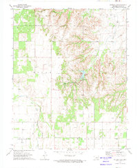
1972 Map of Watonga Lake
USGS Topo · Published 1974About this map
Roman Nose State Park serves as the central focal point of this Oklahoma landscape, where the recreational waters of Watonga Lake and Boecher Lake are set against a backdrop of complex canyon topography. The map illustrates the region's diverse transition from the riparian corridor of the North Canadian River in the west to the higher, gas-producing lands of Carlton and Flynn townships. Transportation history is etched into the terrain through the C R I & P railroad line and an Old Railroad Grade that winds through the central hills. Local heritage is preserved in landmarks such as the Bridgford Cem and Ruby Mill, while the presence of numerous Gas Wells highlights the energy-based economy of the early 1970s. The concentration of facilities around Big Spring Picnic Area and the Lodge indicates a well-established mid-century park infrastructure within the gypsum-rich hills of Blaine County.
Find a feature on this map
31 named features on this map. Tap any name to fly to it.
Don’t see what you’re looking for? This feature index may not catch every label — zoom into the map to look around manually.
Map Details
Editions of this 1972 Watonga Lake Map
This is the sole edition of this map. No revisions or reprints were ever made.
Other maps of this area

1955 · Clinton
USGS Topo · 1:250,000

1955 · Woodward
USGS Topo · 1:250,000

1957 · Clinton
USGS Topo · 1:250,000

1958 · Woodward
USGS Topo · 1:250,000

1964 · Oakwood
USGS Topo · 1:62,500

1972 · Watonga
USGS Topo · 1:24,000

1972 · Canton
USGS Topo · 1:24,000

1972 · Watonga SE
USGS Topo · 1:24,000

1972 · Southard
USGS Topo · 1:24,000

1972 · Okeene
USGS Topo · 1:24,000