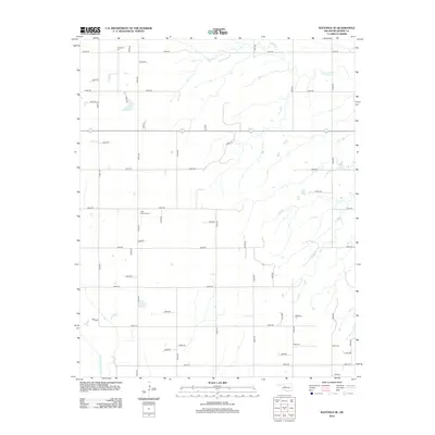
2012 Map of Watonga SE
USGS Topo · Published 2012About this map
Evergreen Cem and E Mt Pleasant Cem anchor the northwestern and central reaches of this Blaine County landscape, reflecting the long-established rural communities of the region. The terrain is defined by the drainage patterns of Kingfisher Cr in the northeast and the North Canadian River cutting through the southwest corner. The area is surveyed with a precise grid of local roads, such as e0790 RD and n2610 RD, which facilitate movement between scattered farmsteads and agricultural plots. In the southeast, Udora Cem provides another point of historical interest for genealogists tracing local lineages. The map illustrates a typical Oklahoma prairie settlement pattern where land use is dictated by the river valleys and the availability of water, maintained through a sophisticated network of county roads.
Find a feature on this map
47 named features on this map. Tap any name to fly to it.
Don’t see what you’re looking for? This feature index may not catch every label — zoom into the map to look around manually.
Map Details
Editions of this 2012 Watonga SE Map
This is the sole edition of this map. No revisions or reprints were ever made.
Other maps of this area

1893 · Fort Reno
USGS Topo · 1:62,500

1893 · Loyal
USGS Topo · 1:62,500

1941 · Fort Reno
USGS Topo · 1:62,500

1942 · Fort Reno
USGS Topo · 1:62,500

1942 · Geary
USGS Topo · 1:62,500

1949 · Fort Reno
USGS Topo · 1:62,500

1955 · Clinton
USGS Topo · 1:250,000

1957 · Clinton
USGS Topo · 1:250,000

1972 · Watonga
USGS Topo · 1:24,000
1972 · Omega
USGS Topo · 1:24,000