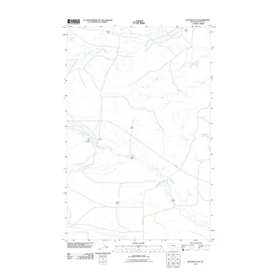
2011 Map of Watson Flats
USGS Topo · Published 2011About this map
Watson Flats defines the central landscape of this Teton County survey, where the prairie topography is carved by a network of drainage coulees and creeks. Ranching activity is anchored by namesake properties like Peebles Ranch in the north and Pearson Ranch near the southern boundary, connected by a sparse grid of rural routes including Peebles Rd and Pearson Rd. The hydrologic pattern is shaped by the winding course of Willow Creek and its various tributaries, which flow through depressions such as Tin Can Coulee and Fowler Coulee. Significant landmarks like Egg Mountain and Poker Butte rise above the flats, providing navigational points in a terrain largely dedicated to open range and water management, evidenced by the Dougcliff Reservoir on the eastern edge. This document captures the intersection of natural watercourses and the established agricultural footprint of the Montana plains.
Find a feature on this map
17 named features on this map. Tap any name to fly to it.
Don’t see what you’re looking for? This feature index may not catch every label — zoom into the map to look around manually.
Map Details
Editions of this 2011 Watson Flats Map
This is the sole edition of this map. No revisions or reprints were ever made.
Other maps of this area

1903 · Saypo
USGS Topo · 1:125,000

1920 · Choteau
USGS Topo · 1:125,000

1955 · Choteau
USGS Topo · 1:250,000

1957 · Choteau
USGS Topo · 1:250,000

1958 · Choteau
USGS Topo · 1:250,000

1958 · Lake Theboe
USGS Topo · 1:24,000
1958 · Twin Lakes
USGS Topo · 1:24,000
1958 · Split Rock Lake
USGS Topo · 1:24,000

1960 · Bynum
USGS Topo · 1:62,500

1960 · Gilman
USGS Topo · 1:62,500