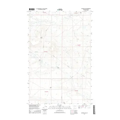
2017 Map of Watson Flats
USGS Topo · Published 2017About this map
Watson Flats sits at the heart of this Teton County landscape, where the prairie is defined by an intricate network of drainage features and coulees. The map illustrates a ranching and agricultural environment where water management is central to the land's utility, evidenced by the Dougcliff Reservoir and the winding course of Willow Cr and its northern and southern forks. The terrain is marked by distinctive local landmarks like Poker Butte and several named coulees, including Hod Main Coulee, Tin Can Coulee, and Fowler Coulee, which serve as natural landmarks across the open range. A sparse network of rural roads such as Peebles Rd, Bellview Rd, and Pearson Rd provides the primary access between these isolated features, following the section lines of the Public Land Survey System through townships T23N to T25N.
Find a feature on this map
21 named features on this map. Tap any name to fly to it.
Don’t see what you’re looking for? This feature index may not catch every label — zoom into the map to look around manually.
Map Details
Editions of this 2017 Watson Flats Map
This is the sole edition of this map. No revisions or reprints were ever made.
Other maps of this area

1903 · Saypo
USGS Topo · 1:125,000

1920 · Choteau
USGS Topo · 1:125,000

1955 · Choteau
USGS Topo · 1:250,000

1957 · Choteau
USGS Topo · 1:250,000

1958 · Choteau
USGS Topo · 1:250,000

1958 · Lake Theboe
USGS Topo · 1:24,000
1958 · Twin Lakes
USGS Topo · 1:24,000
1958 · Split Rock Lake
USGS Topo · 1:24,000

1960 · Bynum
USGS Topo · 1:62,500

1960 · Gilman
USGS Topo · 1:62,500