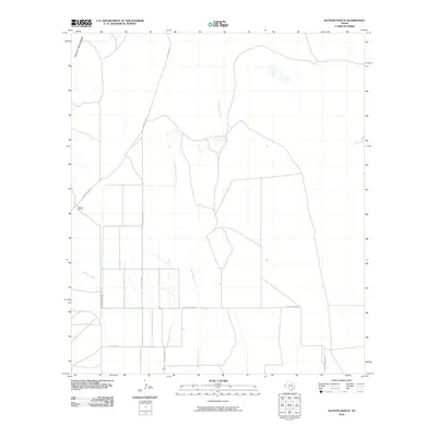
2010 Map of Watson Ranch
USGS Topo · Published 2010About this map
Watson Ranch sits in the high desert basin of West Texas, at a time when traditional ranching infrastructure and modern surveying intersect. The northern boundary of the landscape is defined by the steep slopes of the Baylor Mountains, which give way to a vast alluvial plain. This arid territory is dissected by the ephemeral drainage of Wild Horse Creek, which flows south through the center of the quadrangle, and Sulphur Creek to the west. The grid-like layout of rural transit is established by Whitehead Rd and Richard Keohn Rd, providing essential access to remote homesteads and agricultural operations. A more significant regional connection is made via Ranch Rd 2809, which cuts across the southern portion of the survey, highlighting the importance of the farm-to-market road system in maintaining the connectivity of Culberson County’s isolated ranching communities.
Find a feature on this map
7 named features on this map. Tap any name to fly to it.
Don’t see what you’re looking for? This feature index may not catch every label — zoom into the map to look around manually.
Map Details
Editions of this 2010 Watson Ranch Map
This is the sole edition of this map. No revisions or reprints were ever made.
Other maps of this area

1906 · Van Horn
USGS Topo · 1:125,000

1954 · Van Horn
USGS Topo · 1:250,000

1958 · Van Horn
USGS Topo · 1:250,000
1964 · Goat Canyon
USGS Topo · 1:24,000

1964 · Wild Horse
USGS Topo · 1:24,000

1964 · Watson Ranch
USGS Topo · 1:24,000

1964 · Van Horn
USGS Topo · 1:24,000
1964 · Nutt Ranch
USGS Topo · 1:24,000
1964 · Plateau
USGS Topo · 1:24,000

1972 · Seven Heart Gap
USGS Topo · 1:24,000