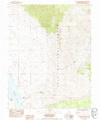
1984 Map of Watterson Canyon
USGS Topo · Published 1984About this map
Long Valley dominates the southwestern portion of this mid-1980s landscape, where the waters of Crowley Lake meet the edge of the Inyo National Forest. The map documents the hydrology of the upper Owens River system, noting a normal water level of 2062 feet for the reservoir. To the north, the terrain rises sharply toward Glass Mtn Ridge, cut by the drainage of Wilfred Canyon and the winding course of Wilfred Creek.
Find a feature on this map
15 named features on this map. Tap any name to fly to it.
Don’t see what you’re looking for? This feature index may not catch every label — zoom into the map to look around manually.
Map Details
Editions of this 1984 Watterson Canyon Map
This is the sole edition of this map. No revisions or reprints were ever made.
Other maps of this area

1914 · Mt. Morrison
USGS Topo · 1:125,000

1947 · Mariposa
USGS Topo · 1:250,000

1948 · Mariposa
USGS Topo · 1:250,000

1953 · Mt. Morrison
USGS Topo · 1:62,500

1953 · Casa Diablo Mtn
USGS Topo · 1:62,500

1957 · Mariposa
USGS Topo · 1:250,000

1962 · Cowtrack Mtn
USGS Topo · 1:62,500

1962 · Glass Mountain
USGS Topo · 1:62,500

1963 · Mariposa
USGS Topo · 1:250,000
1983 · Whitmore Hot Sprs
USGS Topo · 1:24,000