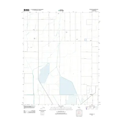
2012 Map of Waukena
USGS Topo · Published 2012About this map
The settlement of Waukena anchors the southeast corner of this Central Valley survey, reflecting a landscape dominated by industrial-scale agriculture and water management. Large-scale dairy operations, including the Kansas Holstein Dairy, Phil Vannette Dairy, and Caetano Dairy, define the local economy alongside the River Ranch to the north. This grid-based terrain is bisected by a complex network of seasonal waterways and irrigation channels, most notably the meandering paths of Cross Cr and Guernsey Slough. Local history is anchored by established landmarks such as the Aurora School and Lakeside Cem, while a precise network of named avenues and roads, from Jersey Ave down to Nevada Ave, provides a detailed view of the rural property divisions and transit corridors used by these large ranching estates.
Find a feature on this map
36 named features on this map. Tap any name to fly to it.
Don’t see what you’re looking for? This feature index may not catch every label — zoom into the map to look around manually.
Map Details
Editions of this 2012 Waukena Map
This is the sole edition of this map. No revisions or reprints were ever made.
Other maps of this area

1926 · Goshen
USGS Topo · 1:31,680

1926 · Hanford
USGS Topo · 1:31,680

1927 · Remnoy
USGS Topo · 1:31,680

1927 · Lake View School
USGS Topo · 1:31,680

1927 · Paige
USGS Topo · 1:31,680

1928 · Waukena
USGS Topo · 1:31,680

1928 · Corcoran
USGS Topo · 1:31,680

1929 · Guernsey
USGS Topo · 1:31,680

1932 · El Rico Ranch
USGS Topo · 1:31,680
1936 · El Rico Ranch
USGS Topo · 1:31,680