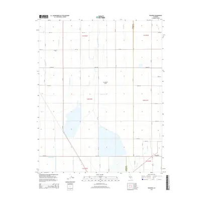
2015 Map of Waukena
USGS Topo · Published 2015About this map
The settlement of Waukena sits at the southeastern corner of this map, serving as a hub for the agricultural grid of the San Joaquin Valley. The landscape is defined by an intricate network of irrigation infrastructure designed to manage water across the flat terrain, including the Guiberson Canal, Highline Canal, and Bean Ditch. Natural drainage features like Guernsey Slough and Cross Creek intersect with these man-made channels, illustrating the massive hydrological engineering required for the region's farming industry. Genealogy researchers may find interest in the Lakeside Cem located along Kent Ave. The map reflects the rigid Township and Range surveying system, with roads such as 9th Ave and Avenue 200 following precise section lines through several townships, including t20s r22e and t21s r23e.
Find a feature on this map
44 named features on this map. Tap any name to fly to it.
Don’t see what you’re looking for? This feature index may not catch every label — zoom into the map to look around manually.
Map Details
Editions of this 2015 Waukena Map
This is the sole edition of this map. No revisions or reprints were ever made.
Other maps of this area

1926 · Goshen
USGS Topo · 1:31,680

1926 · Hanford
USGS Topo · 1:31,680

1927 · Remnoy
USGS Topo · 1:31,680

1927 · Lake View School
USGS Topo · 1:31,680

1927 · Paige
USGS Topo · 1:31,680

1928 · Waukena
USGS Topo · 1:31,680

1928 · Corcoran
USGS Topo · 1:31,680

1929 · Guernsey
USGS Topo · 1:31,680

1932 · El Rico Ranch
USGS Topo · 1:31,680
1936 · El Rico Ranch
USGS Topo · 1:31,680