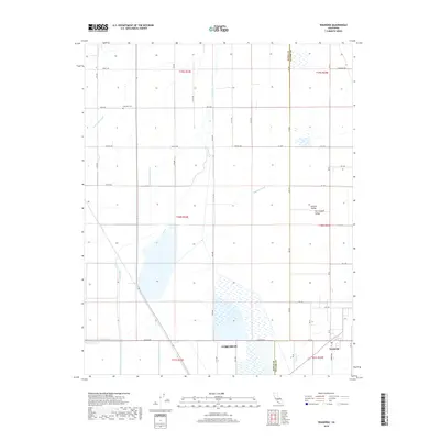
2018 Map of Waukena
USGS Topo · Published 2018About this map
San Joaquin Valley agriculture dominates this landscape near Corcoran, where a complex network of irrigation and drainage infrastructure has reshaped the natural hydrology. The map illustrates how human engineering has managed the flow across the valley floor, featuring extensive works like the Highline Canal, Guiberson Canal, and Bean Ditch. These man-made channels intersect with natural waterways such as Guernsey Slough and Cross Cr, creating a geometric grid of fields and roads. In the southeastern corner, the small settlement of Waukena sits at the junction of local routes, while the Lakeside Cem to the north serves as a quiet landmark amidst the vast tracts of farmland. The distribution of secondary roads and section lines reflects the industrial scale of farming in Kings County during the early 21st century.
Find a feature on this map
34 named features on this map. Tap any name to fly to it.
Don’t see what you’re looking for? This feature index may not catch every label — zoom into the map to look around manually.
Map Details
Editions of this 2018 Waukena Map
This is the sole edition of this map. No revisions or reprints were ever made.
Other maps of this area

1926 · Goshen
USGS Topo · 1:31,680

1926 · Hanford
USGS Topo · 1:31,680

1927 · Remnoy
USGS Topo · 1:31,680

1927 · Lake View School
USGS Topo · 1:31,680

1927 · Paige
USGS Topo · 1:31,680

1928 · Waukena
USGS Topo · 1:31,680

1928 · Corcoran
USGS Topo · 1:31,680

1929 · Guernsey
USGS Topo · 1:31,680

1932 · El Rico Ranch
USGS Topo · 1:31,680
1936 · El Rico Ranch
USGS Topo · 1:31,680