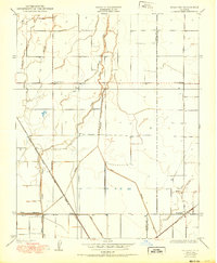
1950 Map of Waukena
USGS Topo · Published 1950About this map
The agricultural landscape of the San Joaquin Valley is defined here by an intricate network of irrigation and water management during the mid-1920s. The settlement of Waukena sits at the intersection of local roads and the Atchison Topeka and Santa Fe railroad, which cuts a sharp diagonal through the grid of section lines. This period shows the reliance on gravity-fed water systems, with features like Lakeside Ditch, Sweet Canal, and Dallas Ditch threading through the fields to manage the natural flow of Cross Creek and Guernsey Slough.
Find a feature on this map
18 named features on this map. Tap any name to fly to it.
Don’t see what you’re looking for? This feature index may not catch every label — zoom into the map to look around manually.
Map Details
Editions of this 1950 Waukena Map
This is the sole edition of this map. No revisions or reprints were ever made.
Other maps of this area

1926 · Goshen
USGS Topo · 1:31,680

1926 · Hanford
USGS Topo · 1:31,680

1927 · Remnoy
USGS Topo · 1:31,680

1927 · Lake View School
USGS Topo · 1:31,680

1927 · Paige
USGS Topo · 1:31,680

1928 · Waukena
USGS Topo · 1:31,680

1928 · Corcoran
USGS Topo · 1:31,680

1929 · Guernsey
USGS Topo · 1:31,680

1932 · El Rico Ranch
USGS Topo · 1:31,680
1936 · El Rico Ranch
USGS Topo · 1:31,680