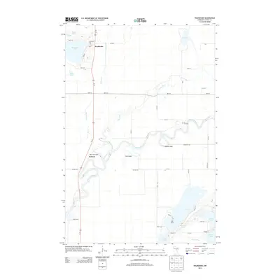
2013 Map of Waukenabo
USGS Topo · Published 2013About this map
Mississippi River bends and oxbows through the heart of this Aitkin County landscape, creating a complex hydrologic network alongside the Willow River and White Elk Cr. The settlement of Waukenabo sits near the northern shore of Waukenabo Lake, serving as a focal point for local history alongside the smaller community of Waldeck to the southwest. This 2013 survey illustrates a region defined by its diverse water bodies, from the larger Gun Lake and Fleming Lake to specialized terrain features like White Elk Logan and Clark Logan. Genealogists will find several key burial sites preserved here, including Waukenabo Cem near the lake of the same name, Pine Grove Cem near a sharp bend in the Mississippi, and Fleming Cem tucked away in the southeastern corner of the quadrangle.
Find a feature on this map
46 named features on this map. Tap any name to fly to it.
Don’t see what you’re looking for? This feature index may not catch every label — zoom into the map to look around manually.
Map Details
Editions of this 2013 Waukenabo Map
This is the sole edition of this map. No revisions or reprints were ever made.
Other maps of this area

1914 · Aitkin
USGS Topo · 1:62,500

1915 · Aitkin
USGS Topo · 1:62,500

1953 · Duluth
USGS Topo · 1:250,000

1958 · Duluth
USGS Topo · 1:250,000

1970 · Kimberly
USGS Topo · 1:24,000

1970 · Palisade
USGS Topo · 1:24,000

1970 · Sanders Lake
USGS Topo · 1:24,000

1970 · Bain
USGS Topo · 1:24,000

1970 · White Elk Lake
USGS Topo · 1:24,000
1973 · Waukenabo
USGS Topo · 1:24,000