
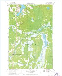
1970 Map of White Elk Lake
USGS Topo · Published 1973About this map
The Hill River State Forest dominates this northern Minnesota landscape, where dense woodlands and extensive wetlands define the local character. At its center lies White Elk Lake, a major water body joined by a network of smaller basins including Mud Lake, Buss Lake, and Wolf Lake. A notable landmark for fire spotting, the White Elk Lookout Tower stands south of the main lake, providing a high vantage point over the forest canopy.
Find a feature on this map
16 named features on this map. Tap any name to fly to it.
Don’t see what you’re looking for? This feature index may not catch every label — zoom into the map to look around manually.
Map Details
Editions of this 1970 White Elk Lake Map
This is the sole edition of this map. No revisions or reprints were ever made.
Other maps of this area

1913 · Cuyuna
USGS Topo · 1:62,500

1914 · Aitkin
USGS Topo · 1:62,500

1915 · Aitkin
USGS Topo · 1:62,500

1915 · Cuyuna
USGS Topo · 1:62,500

1953 · Duluth
USGS Topo · 1:250,000

1958 · Duluth
USGS Topo · 1:250,000

1970 · Edna Lake
USGS Topo · 1:24,000

1970 · Shovel Lake
USGS Topo · 1:24,000

1970 · Bain
USGS Topo · 1:24,000
1970 · Hill City
USGS Topo · 1:24,000