
1970 Map of Edna Lake
USGS Topo · Published 1972About this map
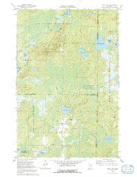
Land O' Lakes State Forest dominates this northern landscape, where a dense network of glacial lakes and river systems defines the geography of Beulah and L I T T L E P I N E townships. The map documents the convergence of three counties—Cass, Aitkin, and Crow Wing—amidst a wilderness of wetlands and peat bogs. The Rice Pad River flows south through Rice Pad Lake and Tank Lake toward the larger Little Pine Lake, illustrating the intricate natural drainage patterns of the region before significant modern development. Cultural features are sparse, limited to scattered roads and a few landmarks like the high ground at Mae or the Sandpit locations near the water. This 1970s survey captures the area as a dedicated conservation and recreation zone, anchored by the Hill River State Forest and the Duck Lake State Wildlife Management Area, preserving the character of the Minnesota Northwoods.
Find a feature on this map
30 named features on this map. Tap any name to fly to it.
Don’t see what you’re looking for? This feature index may not catch every label — zoom into the map to look around manually.
Map Details
Editions of this 1970 Edna Lake Map
2 editions found
Other maps of this area

1913 · Cuyuna
USGS Topo · 1:62,500

1914 · Aitkin
USGS Topo · 1:62,500

1915 · Aitkin
USGS Topo · 1:62,500

1915 · Cuyuna
USGS Topo · 1:62,500

1953 · Duluth
USGS Topo · 1:250,000

1958 · Duluth
USGS Topo · 1:250,000

1970 · Shovel Lake
USGS Topo · 1:24,000
1970 · Roosevelt Lake
USGS Topo · 1:24,000
1970 · Thunder Lake
USGS Topo · 1:24,000

1970 · White Elk Lake
USGS Topo · 1:24,000