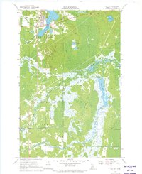
1970 Map of Hill City
USGS Topo · Published 1973About this map
Hill City serves as the focal point of this northern Minnesota landscape, situated at the northern tip of Hill Lake where recreational development and industry meet. The town's layout includes a Golf Course and nearby Ski Lifts on the slopes of Quadna Mountain, which is topped by a Lookout Tower and Radio Tower. The surrounding terrain is a complex network of wetlands and waterways within the Hill River State Forest, characterized by numerous pools and flowages such as the Willow River Pool and Moose River Pool. Evidence of past infrastructure is preserved in the form of an Old RR Grade and several Winter Grades cutting through the forest. To the south, the small settlement of Haypoint and the Macville Cem provide touchstones for local family history in a region defined by the winding paths of the Moose River and Willow River.
Find a feature on this map
34 named features on this map. Tap any name to fly to it.
Don’t see what you’re looking for? This feature index may not catch every label — zoom into the map to look around manually.
Map Details
Editions of this 1970 Hill City Map
This is the sole edition of this map. No revisions or reprints were ever made.
Other maps of this area

1953 · Duluth
USGS Topo · 1:250,000

1954 · Hibbing
USGS Topo · 1:250,000

1957 · Hibbing
USGS Topo · 1:250,000

1958 · Hibbing
USGS Topo · 1:250,000

1958 · Duluth
USGS Topo · 1:250,000

1964 · Hibbing
USGS Topo · 1:250,000

1970 · Split Hand Lake
USGS Topo · 1:24,000

1970 · Rabey
USGS Topo · 1:24,000

1970 · Big Thunder Peak
USGS Topo · 1:24,000
1970 · Mountain Ash Lake
USGS Topo · 1:24,000