
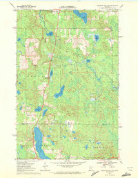
1970 Map of Big Thunder Peak
USGS Topo · Published 1972About this map
Big Thunder Peak rises above the complex glacial terrain of north-central Minnesota, serving as a prominent landmark within the Sugar Hills. This 1970 survey captures the area at a time when recreational development was emerging, evidenced by a Ski Lift near the peak, while the landscape remained dominated by the dense wetlands and woods of the Hill River State Forest. The map documents the intricate hydrology of the region, featuring numerous small basins and larger bodies of water such as Holy Water Lake, Muskeg Lake, and Hill Lake. The southern portion of the sheet marks the boundary between Itasca Co and Aitkin Co, where the Little Hill River and Morrison Brook wind through the lowlands. This survey is particularly useful for identifying the specific network of a Winter Trail used for seasonal access before modern road infrastructure became more pervasive.
Find a feature on this map
16 named features on this map. Tap any name to fly to it.
Don’t see what you’re looking for? This feature index may not catch every label — zoom into the map to look around manually.
Map Details
Editions of this 1970 Big Thunder Peak Map
This is the sole edition of this map. No revisions or reprints were ever made.
Other maps of this area

1953 · Siseebakwet Lake
USGS Topo · 1:24,000

1953 · Grand Rapids
USGS Topo · 1:24,000

1953 · Duluth
USGS Topo · 1:250,000

1954 · Hibbing
USGS Topo · 1:250,000

1957 · Hibbing
USGS Topo · 1:250,000

1958 · Hibbing
USGS Topo · 1:250,000

1958 · Duluth
USGS Topo · 1:250,000

1964 · Hibbing
USGS Topo · 1:250,000

1970 · Shovel Lake
USGS Topo · 1:24,000
1970 · Mountain Ash Lake
USGS Topo · 1:24,000