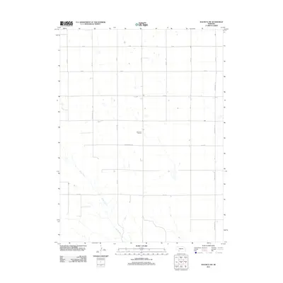
2011 Map of Wauneta SW
USGS Topo · Published 2011About this map
Mount Zion Cemetery sits at the heart of this agricultural landscape in Chase County, serving as a quiet landmark amidst a strictly organized grid of rural section roads. The terrain is defined by the winding course of Muddy Creek, which cuts diagonally across the southern portion of the quadrangle, breaking the geometric regularity of the surrounding fields. Unlike the rigid paths of 727 Rd and 340 Ave, the creek bed introduces a natural, meandering element to the topography.
Find a feature on this map
16 named features on this map. Tap any name to fly to it.
Don’t see what you’re looking for? This feature index may not catch every label — zoom into the map to look around manually.
Map Details
Editions of this 2011 Wauneta SW Map
This is the sole edition of this map. No revisions or reprints were ever made.
Other maps of this area

1954 · McCook
USGS Topo · 1:250,000

1957 · McCook
USGS Topo · 1:250,000

1958 · McCook
USGS Topo · 1:250,000

1962 · Max NE
USGS Topo · 1:24,000

1973 · Enders
USGS Topo · 1:24,000

1973 · Ough
USGS Topo · 1:24,000

1973 · Wauneta SW
USGS Topo · 1:24,000
1973 · Rock Canyon
USGS Topo · 1:24,000

1973 · Wauneta SE
USGS Topo · 1:24,000
1973 · Arrowhead Lake
USGS Topo · 1:24,000