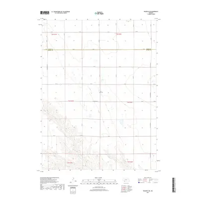
2017 Map of Wauneta SW
USGS Topo · Published 2017About this map
Muddy Creek carves a distinctive path through this section of Southwest Nebraska, where the high plains terrain meets the Chase County and Dundy County border. The landscape is defined by a rigorous grid of section lines and rural routes, reflecting a history of dryland farming and ranching development. A central landmark for local history and genealogy is Mount Zion Cemetery, situated near the intersection of Ave 343 and RD 724. The map illustrates the sophisticated network of township roads, including named thoroughfares like Neighborhood Road and Max-Wauneta Road, which link the isolated farmsteads of the high prairie. The sharp relief shown along the creek bed contrasts with the level upland plateaus, providing a clear picture of the region's physical geography in the early twenty-first century.
Find a feature on this map
30 named features on this map. Tap any name to fly to it.
Don’t see what you’re looking for? This feature index may not catch every label — zoom into the map to look around manually.
Map Details
Editions of this 2017 Wauneta SW Map
This is the sole edition of this map. No revisions or reprints were ever made.
Other maps of this area

1954 · McCook
USGS Topo · 1:250,000

1957 · McCook
USGS Topo · 1:250,000

1958 · McCook
USGS Topo · 1:250,000

1962 · Max NE
USGS Topo · 1:24,000

1973 · Enders
USGS Topo · 1:24,000

1973 · Ough
USGS Topo · 1:24,000

1973 · Wauneta SW
USGS Topo · 1:24,000
1973 · Rock Canyon
USGS Topo · 1:24,000

1973 · Wauneta SE
USGS Topo · 1:24,000
1973 · Arrowhead Lake
USGS Topo · 1:24,000