
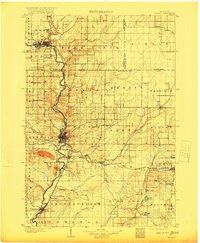
1902 Map of Wausau
USGS Topo · Published 1902About this map
The Wisconsin River corridor serves as the industrial spine of this 1902 survey, connecting the primary manufacturing centers of Wausau and Merrill. This turn-of-the-century landscape is defined by the logistics of the timber industry, evident in the network of the Chicago Milwaukee and St Paul Ry and specialized features like Bull Dessert Logging Creek. The map documents a period of significant institutional and industrial growth, locating the State Insane Asylum south of Wausau and various granite quarries and lumber-adjacent settlements such as Granite Heights and Schofield. Away from the main river valley, the topography rises toward B B Hill and Marshall Hill, while the eastern portion of the sheet reveals a more dispersed settlement pattern around Hogarty and Nutterville, where early rural post offices and small rail junctions like Dessert Junction once anchored local life.
Find a feature on this map
73 named features on this map. Tap any name to fly to it.
Don’t see what you’re looking for? This feature index may not catch every label — zoom into the map to look around manually.
Map Details
Editions of this 1902 Wausau Map
2 editions found
Other maps of this area

1899 · Wausau
USGS Topo · 1:125,000

1902 · Marathon
USGS Topo · 1:125,000

1940 · Parrish
USGS Topo · 1:48,000

1942 · Elcho
USGS Topo · 1:48,000

1950 · Elcho
USGS Topo · 1:48,000

1950 · Parrish
USGS Topo · 1:48,000

1950 · Tomahawk
USGS Topo · 1:48,000

1950 · Spirit Falls
USGS Topo · 1:48,000

1951 · Doering
USGS Topo · 1:48,000

1951 · Merrill
USGS Topo · 1:48,000