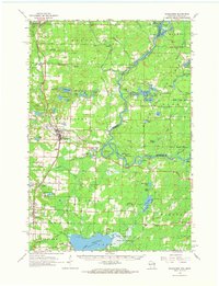
1963 Map of Wausaukee
USGS Topo · Published 1964About this map
The Menominee River serves as a natural boundary between Wisconsin and Michigan in this mid-century survey, winding through a landscape defined by timber and water. The Chicago Milwaukee St Paul and Pacific RR provides a north-south industrial spine, connecting the communities of Amberg, Cedarville, Wausaukee, and Middle Inlet. To the east, the Shakey Lakes Park and the rugged topography of Bear Mountain and Oak Hill suggest a region transitioning into conservation and recreation. Notable local landmarks include the Middle Inlet Lookout Tower and the curiously named Sweetheart City south of Wausaukee. The southern portion is dominated by the northern reaches of the Lake Noquebay Wildlife Area, while various gravel pits scattered near the rail line indicate the local extractive activity of the era. Genealogists will find cemetery sites like Pinehill Cem and Amberg Cem alongside small community Church of Christ locations.
Find a feature on this map
85 named features on this map. Tap any name to fly to it.
Don’t see what you’re looking for? This feature index may not catch every label — zoom into the map to look around manually.
Map Details
Editions of this 1963 Wausaukee Map
This is the sole edition of this map. No revisions or reprints were ever made.
Other maps of this area

1939 · Marinette
USGS Topo · 1:48,000

1939 · Pembine
USGS Topo · 1:48,000

1939 · Porterfield
USGS Topo · 1:48,000

1939 · Dunbar
USGS Topo · 1:48,000

1940 · Athelstane
USGS Topo · 1:48,000

1941 · Dunbar
USGS Topo · 1:48,000

1941 · Coleman
USGS Topo · 1:48,000

1942 · Athelstane
USGS Topo · 1:48,000

1942 · Coleman
USGS Topo · 1:48,000

1942 · Porterfield
USGS Topo · 1:48,000