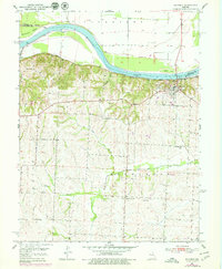
1951 Map of Waverly
USGS Topo · Published 1979About this map
The Missouri River corridor near the Carroll and Lafayette County line defines this landscape, where the river's path is marked by substantial islands like Baltimore Island and Rabbit Island. In the early 1950s, the town of Waverly served as a key hub on the southern bluffs, overlooking the Missouri Pacific railroad tracks that skirted the water. The surrounding uplands are characterized by the meandering Salt Fork and smaller tributaries like Willow Branch and Cragg Branch, which carved the rolling terrain where rural life was centered around local institutions. Researchers will find the locations of several country schools, including Brown Sch, Hazel Hill Sch, and Centerview Sch, alongside community landmarks such as Three Groves Ch and the Catron Cem. This survey illustrates the relationship between the river's floodplain, industrial activity at the local Quarry, and the agricultural settlement patterns typical of mid-century Missouri.
Find a feature on this map
20 named features on this map. Tap any name to fly to it.
Don’t see what you’re looking for? This feature index may not catch every label — zoom into the map to look around manually.
Map Details
Editions of this 1951 Waverly Map
4 editions found

Other maps of this area

1889 · Lexington
USGS Topo · 1:125,000

1890 · Marshall
USGS Topo · 1:125,000

1892 · Marshall
USGS Topo · 1:125,000

1901 · Marshall
USGS Topo · 1:125,000

1950 · Dover
USGS Topo · 1:24,000
1951 · Dover
USGS Topo · 1:24,000

1951 · Alma
USGS Topo · 1:24,000
1951 · Higginsville
USGS Topo · 1:24,000

1951 · Carrollton East
USGS Topo · 1:24,000

1951 · Waverly
USGS Topo · 1:24,000