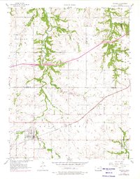
1957 Map of Waverly
USGS Topo · Published 1976About this map
The railroad community of Waverly serves as the focal point of this mid-century survey of the Kansas prairie, situated at the junction of the Atchison Topeka and Santa Fe and the Old Railroad Grade. This transport hub, marked by a detailed grid of streets and the Waverly Cem, reflects the agricultural economy of the Osage and Coffey County line. To the northeast, the smaller settlement of Agricola sits along the tracks, near the Pleasant View Cem.
Find a feature on this map
26 named features on this map. Tap any name to fly to it.
Don’t see what you’re looking for? This feature index may not catch every label — zoom into the map to look around manually.
Map Details
Editions of this 1957 Waverly Map
2 editions found

Other maps of this area

1885 · Burlington
USGS Topo · 1:125,000

1885 · Garnett
USGS Topo · 1:125,000

1885 · Lawrence
USGS Topo · 1:125,000

1889 · Burlingame
USGS Topo · 1:125,000

1889 · Lawrence
USGS Topo · 1:125,000

1894 · Garnett
USGS Topo · 1:125,000

1894 · Burlingame
USGS Topo · 1:125,000

1894 · Burlington
USGS Topo · 1:125,000

1947 · Lawrence
USGS Topo · 1:250,000

1950 · Lawrence
USGS Topo · 1:250,000