1943 Map of Wawayanda
USGS Topo · Published 1943About this map
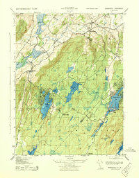
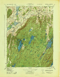
Wawayanda Mountain and Pochuck Mountain dominate this mid-century landscape along the New York-New Jersey border. The area is characterized by a high concentration of water bodies, including Wawayanda Lake, Upper Greenwood Lake, and the Canistear Reservoir. Small settlements and agricultural junctions like Blooms Corners, Maple Grange, and De Kays are connected by a network of rural roads such as Long House Road.
Find a feature on this map
37 named features on this map. Tap any name to fly to it.
Don’t see what you’re looking for? This feature index may not catch every label — zoom into the map to look around manually.
Map Details
Editions of this 1943 Wawayanda Map
2 editions found
Other maps of this area

1888 · Franklin
USGS Topo · 1:62,500

1891 · Greenwood Lake
USGS Topo · 1:62,500

1893 · Greenwood Lake
USGS Topo · 1:62,500

1894 · Franklin
USGS Topo · 1:62,500

1897 · Franklin
USGS Topo · 1:62,500

1903 · Franklin Furnace
USGS Topo · 1:62,500

1903 · Greenwood Lake
USGS Topo · 1:62,500

1906 · Port Jervis
USGS Topo · 1:62,500

1906 · Goshen
USGS Topo · 1:62,500

1908 · Goshen
USGS Topo · 1:62,500