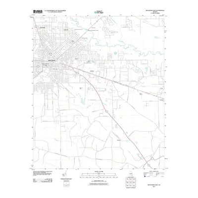
2011 Map of Waycross East
USGS Topo · Published 2011About this map
Waycross serves as the focal point of this 2011 survey, showing the city's reach toward the eastern wetlands and the Satilla River. The map documents a diverse landscape of residential expansion and rural industry, where the University of Georgia Waycross Post Office and Okefenokee Fairgrounds mark the city's institutional presence. Moving east and south, the grid of the city gives way to a network of winding waterways and family-named landmarks. The drainage of Mill Creek and Double Branches defines the low-lying terrain, punctuated by significant local sites like Oakland Cemetery and the outlying settlement of Astoria. This edition captures the infrastructure of the early 21st century, from the Waycross-Blackshear Bridge to the small-scale operations at Bivins Airport, reflecting the region's continued role as a South Georgia transit and agricultural hub.
Find a feature on this map
58 named features on this map. Tap any name to fly to it.
Don’t see what you’re looking for? This feature index may not catch every label — zoom into the map to look around manually.
Map Details
Editions of this 2011 Waycross East Map
This is the sole edition of this map. No revisions or reprints were ever made.
Other maps of this area

1953 · Waycross
USGS Topo · 1:250,000

1958 · Waycross
USGS Topo · 1:250,000

1967 · Waycross SE
USGS Topo · 1:24,000
1967 · Fort Mudge
USGS Topo · 1:24,000

1967 · Hoboken West
USGS Topo · 1:24,000

1967 · Waycross West
USGS Topo · 1:24,000

1967 · Waycross East
USGS Topo · 1:24,000

1967 · Waycross SW
USGS Topo · 1:24,000

1971 · Dixie Union
USGS Topo · 1:24,000

1971 · Blackshear East
USGS Topo · 1:24,000