
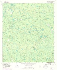
1967 Map of Waycross SW
USGS Topo · Published 1969About this map
Pittman Chapel and the nearby Carter Cem anchor the small human presence in this dense swamp landscape along the Ware and Charlton County border. The environment is dominated by the northern reaches of the Okefenokee National Wildlife Refuge, where a complex system of islands and water bodies like Bush Island, Cane Break Island, and Tom Thumb Bay illustrate the intricate hydrology of the Georgia coastal plain. Transportation patterns follow historical paths of industry and access, marked by an Old Railroad Grade and the Swamp Perimeter Road. Distance markers like Twelvemile Post and Fifteenmile Post along the grades suggest a landscape measured by its depth into the wetlands, where named features such as Botherment and Berry Belly Strand provide unique local identifiers for specific tracts of this water-bound wilderness.
Find a feature on this map
36 named features on this map. Tap any name to fly to it.
Don’t see what you’re looking for? This feature index may not catch every label — zoom into the map to look around manually.
Map Details
Editions of this 1967 Waycross SW Map
2 editions found
Other maps of this area

1953 · Waycross
USGS Topo · 1:250,000

1954 · Valdosta
USGS Topo · 1:250,000

1958 · Valdosta
USGS Topo · 1:250,000

1958 · Waycross
USGS Topo · 1:250,000

1959 · Valdosta
USGS Topo · 1:250,000

1965 · Dinner Pond
USGS Topo · 1:24,000

1966 · Cravens Island
USGS Topo · 1:24,000

1967 · Waycross SE
USGS Topo · 1:24,000

1967 · Spooner
USGS Topo · 1:24,000

1967 · Waycross West
USGS Topo · 1:24,000