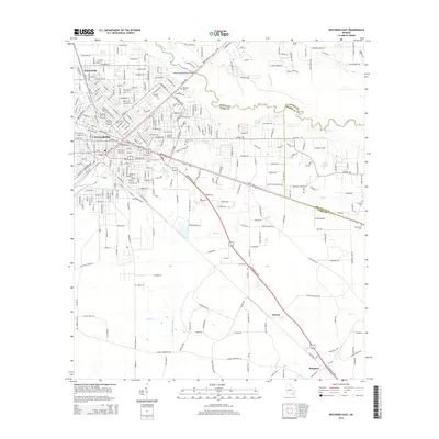
2014 Map of Waycross East
USGS Topo · Published 2014About this map
The Satilla River carves a winding path across this Southeast Georgia landscape, defining the jurisdictional boundaries between Ware, Pierce, and Brantley counties. In the western portion of the sheet, the city of Waycross exhibits a dense grid of residential and industrial streets, including Carswell Ave and Memorial Dr. This 2014 survey documents the transition from the urban core of the city to the outlying rural settlements of Astoria and Braganza to the southeast. Genealogists will find several burial grounds noted, such as Oakland Cem, Red Oak Cem, and Hazzard Hill Cem. Significant water features like Monroe Pond and the Williams Cut highlight the low-lying, hydrologically complex terrain surrounding the river. Small airfields such as Bivins Airport and infrastructure like the Waycross-Blackshear Bridge serve as vital connectors for this regional hub in the early 21st century.
Find a feature on this map
122 named features on this map. Tap any name to fly to it.
Don’t see what you’re looking for? This feature index may not catch every label — zoom into the map to look around manually.
Map Details
Editions of this 2014 Waycross East Map
This is the sole edition of this map. No revisions or reprints were ever made.
Other maps of this area

1953 · Waycross
USGS Topo · 1:250,000

1958 · Waycross
USGS Topo · 1:250,000

1967 · Waycross SE
USGS Topo · 1:24,000
1967 · Fort Mudge
USGS Topo · 1:24,000

1967 · Hoboken West
USGS Topo · 1:24,000

1967 · Waycross West
USGS Topo · 1:24,000

1967 · Waycross East
USGS Topo · 1:24,000

1967 · Waycross SW
USGS Topo · 1:24,000

1971 · Dixie Union
USGS Topo · 1:24,000

1971 · Blackshear East
USGS Topo · 1:24,000