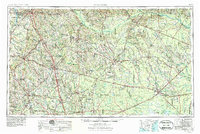
1978 Map of Waycross
USGS Topo · Published 1982This historical map portrays the area of Waycross in 1978, primarily covering Ware County as well as portions of Coffee County, Charlton County, Bacon County, Wayne County, Lanier County, Atkinson County, Clinch County, Pierce County, Appling County, and Brantley County. Featuring a scale of 1:100000, this map provides a highly detailed snapshot of the terrain, roads, buildings, counties, and historical landmarks in the Waycross region at the time. Published in 1982, it is the sole known edition of this map.
Find a feature on this map
108 named features on this map. Tap any name to fly to it.
Don’t see what you’re looking for? This feature index may not catch every label — zoom into the map to look around manually.
Map Details
Editions of this 1978 Waycross Map
This is the sole edition of this map. No revisions or reprints were ever made.
Historical Maps of Mershon Through Time
4 maps found