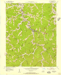
1954 Map of Wayland
USGS Topo · Published 1956About this map
Right Fork Beaver Creek and its many winding tributaries define the settlement patterns of this eastern Kentucky coal country during the mid-1950s. The industrial character of the valley is evident in the presence of the Chesapeake and Ohio railway lines, which connect specialized sites like Porter Junction and Welce Sta. Local life centers around a dense network of small communities and rural institutions, including the Stumbo Memorial Hospital and the Steele Shop Incline near Wayland.
Find a feature on this map
77 named features on this map. Tap any name to fly to it.
Don’t see what you’re looking for? This feature index may not catch every label — zoom into the map to look around manually.
Map Details
Editions of this 1954 Wayland Map
3 editions found
Other maps of this area

1886 · Prestonsburg
USGS Topo · 1:125,000

1890 · Whitesburg
USGS Topo · 1:125,000

1892 · Whitesburg
USGS Topo · 1:125,000

1892 · Prestonsburg
USGS Topo · 1:125,000

1912 · Hindman
USGS Topo · 1:48,000

1914 · Laynesville
USGS Topo · 1:48,000

1914 · Vergie
USGS Topo · 1:48,000

1915 · Prestonsburg
USGS Topo · 1:62,500

1915 · Hindman
USGS Topo · 1:62,500

1916 · Harold
USGS Topo · 1:62,500